Unfortunately all my batteries were exhausted within minutes of arriving at this church.


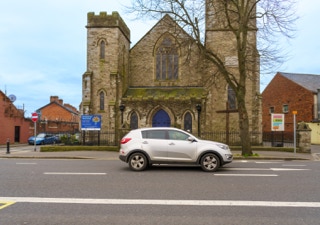
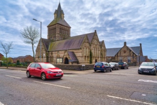
The Jesuits moved into the current house in 1862 and started building the church in 1864. 


It was begun during the rectorship of Fr. Thomas Kelly. The church was dedicated in 1869, although still unfinished in 1897. Designed by William Edward Corbett and supervised by Charles Geoghegan on the site of Crescent House. 


It breaks the uniformity of The Crescent, giving it a focus and adding interest to the Georgian fabric. In 1867, Charles Lanyon and John McCurdy were the arbitrators and Sir John Benson the umpire, in the arbitration case of the failure of the roof of the new church. The builders were Mssers Ryan & Son. In 1900 William Henry Byrne made designs for a proposed façade. 


In 1922 Patrick Joseph Sheahan designed a chapel within the church. In 1938 Patrick Joseph Sheahan was responsible for the painting and decoration with the architectural firm Sheahan & Clery. The building of the church utilised the natural focus of the crescent form to give the prominence that the church needed. The very fine classical interior, with a wealth of quality materials and craftsmanship, adds to the overall architectural importance of this ecclesiastical site.


The Crescent is one of the highlights of Georgian Limerick. The area takes its name from the shape of the terraced buildings on both sides. The two sides combined give the street a distinctive crescent oval shape. The Crescent was originally known as Richmond Place (after Charles Lennox, 4th Duke of Richmond). A monument to Daniel O'Connell; the 19th Century Irish political leader stands at the centre of The Crescent overlooking O'Connell Street. On the west side is the Church of the Sacred Heart, a former Jesuit church that closed in 2006. In 2012 the church was bought by a new religious order known as the Institute of Christ the King Sovereign Priest who hope to restore the church. Adjoining the Church of the Sacred Heart was Crescent College run by the Jesuit Order. It is now located in Dooradoyle suburbs. The site is now occupied by Limerick Tutorial College, a fee paying private school.


CHURCH OF THE SACRED HEART LIMERICK 001
CHURCH OF THE SACRED HEART LIMERICK 002
CHURCH OF THE SACRED HEART LIMERICK 003
CHURCH OF THE SACRED HEART LIMERICK 004

SAINT JOSEPH'S STREET - EMMET PLACE


According to Google Maps this pub has ceased trading. I noticed that they have spelled Emmet as Emmett.


St. Joseph Street (formerly Richmond Street), so named because of its proximity to St. Joseph’s Church.


This pub was owned and operated by Eric and Florence Lynch but unfortunately, for health reasons, they decided to close it in 1997. Florence and Eric, who passed away within a year of each other and were very well known and much liked in Limerick.


This pub was the first  in Limerick to have music, the first to get a music licence. The pub was also famous for its 10 pence a game pool table and they owners maintained  the price at 10 pence for decades. Back in the early 70/80’s it was also one of the first pubs to show movies as they got a Betamax player when they first became available. [Note: Betamax was launched May 10 1975].


ERIC'S PUB IN LIMERICK  001
ERIC'S PUB IN LIMERICK  002

Unfortunately, these photographs contain a lot of noise.


The camera lens combination that I used in March 2019 was not really suitable for night photography so I delayed processing the images until now [8 September 2022].


The Lagan Weir, in Belfast, Northern Ireland, crosses the River Lagan between the Queen Elizabeth Bridge and the M3 cross-harbour bridge. Prior to the building of the weir, the river would be subject to tidal fluctuations, and low tide would expose mudflats, which were unsightly and emitted a strong odour, particularly in the summer months. Opened in 1994, the weir was seen by the Laganside Corporation as a catalyst for its redevelopment projects and was judged to be the "centrepiece" of that effort. The weir also incorporates a footbridge.


The five weir gates can each be operated independently. They are usually raised as the tide retreats in order to keep the river at a specific impoundment level. The gate operations are controlled by the River Manager. Without the weir, the river would be subject to tidal fluctuations. The tidal range is typically up to three metres between high and low tide, but the maximum tidal range can be as much as four metres. Prior to the building of the weir, low tide would expose mudflats, which were unsightly and emitted a strong odour, particularly in the summer months. On occasion, at high tide, the weir can operate as a barrage. If the river level is too high this can have such negative effects as causing erosion of the river banks, reduce air draft for vessels needing to pass under any of the river's road bridges and in extreme cases, increase the risk of flooding to low areas.


A pedestrian footbridge was constructed over the weir and connects Donegall Quay with Queen's Quay. The original bridge, which was narrow and required spiral access ramps at either end, was located above the weir gates and supported by the weir gatehouse structures. This was removed in 2014 to allow the construction a new structure, which provides access for both cyclists and pedestrians. The new bridge was erected by Graham Construction at a cost of £5m and is approximately 8 meters wide at its widest point.


THE LAGAN WEIR IN BELFAST 001
THE LAGAN WEIR IN BELFAST 002
THE LAGAN WEIR IN BELFAST 003
THE LAGAN WEIR IN BELFAST 004
THE LAGAN WEIR IN BELFAST 005
THE LAGAN WEIR IN BELFAST 006
THE LAGAN WEIR IN BELFAST 007
THE LAGAN WEIR IN BELFAST 008
THE LAGAN WEIR IN BELFAST 009
THE LAGAN WEIR IN BELFAST 010
THE LAGAN WEIR IN BELFAST 011
THE LAGAN WEIR IN BELFAST 012
THE LAGAN WEIR IN BELFAST 013
THE LAGAN WEIR IN BELFAST 014
THE LAGAN WEIR IN BELFAST 015
THE LAGAN WEIR IN BELFAST 016
THE LAGAN WEIR IN BELFAST 017
THE LAGAN WEIR IN BELFAST 018
THE LAGAN WEIR IN BELFAST 019
THE LAGAN WEIR IN BELFAST 020
THE LAGAN WEIR IN BELFAST 021
THE LAGAN WEIR IN BELFAST 022
THE LAGAN WEIR IN BELFAST 023
THE LAGAN WEIR IN BELFAST 024
THE LAGAN WEIR IN BELFAST 025
THE LAGAN WEIR IN BELFAST 026
THE LAGAN WEIR IN BELFAST 027
THE LAGAN WEIR IN BELFAST 028
THE LAGAN WEIR IN BELFAST 029
THE LAGAN WEIR IN BELFAST 030
THE LAGAN WEIR IN BELFAST 031
THE LAGAN WEIR IN BELFAST 032
THE LAGAN WEIR IN BELFAST 033
THE LAGAN WEIR IN BELFAST 034
THE LAGAN WEIR IN BELFAST 035
THE LAGAN WEIR IN BELFAST 036
THE LAGAN WEIR IN BELFAST 037
THE LAGAN WEIR IN BELFAST 038

IN 2016 I VISITED CLIFTONPARK AVENUE IN BELFAST TO PHOTOGRAPH THIS CHURCH


The number and variety of churches in Belfast never fails to surprise me.


In 1998, the Ulster History Circle unveiled a commemorative blue plaque to Chaim Herzog [who later went on to become President of Israel between 1983 and 1993] at his birthplace on Cliftonpark Avenue. The plaque was removed by the Circle from the building in August 2014, at the request of the Cliftonville Community Regeneration Forum, who are based there. The plaque had become the subject of unwelcome attention, and in the interests of health and safety it was taken away for safe keeping, until such time as it can be reinstated, with the consent of the owners and occupiers of the premises.


The Ulster History Circle is a heritage organisation that administers Blue Plaques for the area that encompasses the province of Ulster on the island of Ireland. It is a voluntary, not-for-profit organisation, placing commemorative plaques in public places in honour of people and locations that have contributed to all genres of history within the boundary of the Irish province of Ulster, or contemporary country of Northern Ireland. Founded in the early 1980s, the group receives no government funding, unlike many similar organisations in the United Kingdom.


Major-General Chaim Herzog (17 September 1918 – 17 April 1997)was an Irish-born Israeli politician, general, lawyer and author who served as the sixth President of Israel between 1983 and 1993. Born in Belfast and raised primarily in Dublin, the son of Ireland's Chief Rabbi Yitzhak HaLevi Herzog, he immigrated to Mandatory Palestine in 1935 and served in the Haganah Jewish paramilitary group during the 1936–1939 Arab revolt. He returned to Palestine after the war and, following the end of the British Mandate and Israel's Declaration of Independence in 1948, fought in the Battles of Latrun during the 1948 Arab–Israeli War. He retired from the Israel Defence Forces in 1962 with the rank of major-general.


Note: The Belfast Jewish Community established a Jewish Hostel in Cliftonpark Avenue, Belfast, Co. Antrim in the late 1930s as refugees began to escape persecution in Europe.


THE ARC CHURCH IN BELFAST 001
THE ARC CHURCH IN BELFAST 002
THE ARC CHURCH IN BELFAST 003
THE ARC CHURCH IN BELFAST 004
THE ARC CHURCH IN BELFAST 005

YOGA LESSON SCULPTURE BY MICHAEL DISLEY


The bold, colourful Arches Centre is a beacon of health and regeneration for its east Belfast neighbourhood. It is one of three new Community Treatment and Care Centres designed to provide a range of health and social care services under one roof.


Outside the Arches Centre in Belfast  Michael Disley’s highly visible and cheerful Yoga Lesson sculpture is made of concrete and depicts a child in a flower-print dress performing a hand stand.


In the past 25 years Michael over a hundred public works all across the UK and Ireland. In 1993 he went to Africa to live and work with the Shona carvers in Zimbabwe. More recently he travelled extensively to Japan, China, and India to discover new materials, techniques and cultures.


YOGA LESSON SCULPTURE BY MICHAEL DISLEY 001
YOGA LESSON SCULPTURE BY MICHAEL DISLEY 002
YOGA LESSON SCULPTURE BY MICHAEL DISLEY 003

UPPER NEWTOWNARDS ROAD BELFAST MARCH 2019


Photographs showing Kirkpatrick Memorial Presbyterian church, at Ballyhackamore. It was completed in 1927 and may have replaced Ormiston Presbyterian church which was on a nearby site.


My first visit was in March 2019 but I was not happy with the photographs, I damaged my camera when I fell, so I planned to return again in 2020 but was unable to do so because of Covid-19 travel restrictions.


KIRKPATRICK MEMORIAL PRESBYTERIAN CHURCH  001
KIRKPATRICK MEMORIAL PRESBYTERIAN CHURCH  002

PHOTOGRAPHED MARCH 2019


This church was established in 1868. It was damaged during Blitz in 1941 and later restored.


St Mary’s Parish Church, Crumlin Road, Belfast, celebrated the  150th anniversary of its consecration with a Service of Thanksgiving on November 25 not long before my visit in March 2019.


It is described as a gothic style high Victorian Church, with an enormous central tower, designed by London architect William Slater, It and was intended to accommodate 800 worshippers.


It is built of Mourne granite and sandstone and cost £6,500 to build.


The five stained glass windows in the Sanctuary were presented by Mrs Blakiston-Houston and her son, Mr J Blakiston-Houston.


The first housing in the area sprang up in the 1860s to accommodate the workforce and their families who were mainly employed in the thriving linen industry on the Crumlin Road. Unfortunately, the closure of the mills in the 1960s hastened the physical and social decline and of the area.


The Crumlin Road is a main road in north-west Belfast, Northern Ireland. The road runs from north of Belfast City Centre for about four miles to the outskirts of the city. It also forms part of the longer A52 road which leads out of Belfast to the town of Crumlin (from Irish: Cromghlinn, meaning 'crooked glen').  The lower section of the road houses a number of historic buildings, including the city's former law courts and prison, whilst the road encompasses several large housing areas, including Ardoyne, Ballysillan and Ligoniel.


SAINT MARY'S CHURCH CRUMLIN ROAD BELFAST 001
SAINT MARY'S CHURCH CRUMLIN ROAD BELFAST 002
SAINT MARY'S CHURCH CRUMLIN ROAD BELFAST 003
SAINT MARY'S CHURCH CRUMLIN ROAD BELFAST 004
SAINT MARY'S CHURCH CRUMLIN ROAD BELFAST 005
SAINT MARY'S CHURCH CRUMLIN ROAD BELFAST 006

PHOTOGRAPHED MARCH 2019


Glider is a bus rapid transit system in Belfast designed to improve the efficiency of mass transit in the city by connecting East and West Belfast and the Titanic Quarter via the city centre. The service is operated by Translink.


There are two routes, G1 and G2. The busways total 15.2 miles (24.5 km) in length and consist of both dedicated bus lanes and mixed traffic lanes. Constructed at a cost of approximately £100m some of which was provided by the EU.  It operates a fleet of 18m-long Van Hool ExquiCity articulated buses. The first services of the day commence at 5:21am, and the final services depart at 11:06pm. Services operate on a 7-9 minute interval, reducing to 4-6 minutes at peak times.


The vehicles are Van Hool ExquiCity 18 articulated buses of a light tram design with three doors and approximately 18 metres in length. The interior is a mixture of seating and standing, free WI-FI, real-time visual and audible information and CCTV to ensure safety. The diesel hybrid electrical engines emit a low level of pollution and noise complying with environmental concerns. In October, 2017, the specific vehicle, called the Glider, was unveiled at the Busworld Europe exhibition in Belgium.

GLIDER RAPID TRANSIT 001
GLIDER RAPID TRANSIT 002
GLIDER RAPID TRANSIT 003
GLIDER RAPID TRANSIT 004
GLIDER RAPID TRANSIT 005
GLIDER RAPID TRANSIT 006
GLIDER RAPID TRANSIT 007
GLIDER RAPID TRANSIT 008
GLIDER RAPID TRANSIT 009
GLIDER RAPID TRANSIT 010
GLIDER RAPID TRANSIT 011
GLIDER RAPID TRANSIT 012

NEWTOWNARDS ROAD MARCH 2019


This image demonstrates just how much the Harland and Wolff cranes Samson & Goliath dominate the Belfast skyline.


According to contacts in Belfast the Newtownards Road is generally safe and well lit at night. One potential flashpoint is the interface with the nationalist Short Strand neighbourhood. Though fairly well kept and safe during the day, it is best to avoid this area at night.


According to a local that I had a chat with this large Church of Ireland Parish Church was rebuilt after the War to the original plans, having been destroyed in the Blitz.


Here is an extract from the churche's mission statement: Due to the extensive redevelopment and the ’Troubles', the demography of the area has changed enormously in recent years and is still grappling with regeneration. This may explain why I found the area to be more than a little bit confusing.


Ballymacarrett or Ballymacarret (from Irish Baile Mhic Gearóid 'MacGearóid's settlement') is the name of both a townland and electoral ward in Belfast. The townland is in County Down and the electoral ward is part of the Titanic district electoral area of Belfast City Council.


The ward was created in 1973 with most of the population coming from the former Pottinger ward. The ward was slightly enlarged in 1985, taking in part of the Island ward.


The ward consists of two distinct districts : Ballymacarrett itself, which is almost entirely Protestant, and the Short Strand which is almost entirely Catholic, with the two separated by a peaceline. Consequently, in the 2001 census, the Roman Catholic community background figure was 51%.


Set in the shadows of the Harland and Wolff cranes Samson & Goliath, large numbers of local men worked in the shipyard during its heyday. The area is also well known for 'Ulster's Freedom Corner', a series of loyalist murals.


Ballymacarrett and the nearby Newtownards Road played a key part in what became known as the 2011 Northern Ireland riots. At first, the riots were only located in the area and were known as the 2011 East Belfast riots but by July, the riots had spread to other parts of the region. 


Religion, Church, St. Patrick's, Church Of Ireland,destroyed in the Blitz,East Belfast,Newtownards Road,Ballymacarrett,Ballymacarret, MacGearóid's settlement,Harland and Wolff cranes, Samson & Goliath, Belfast,March,2019,Post Industrial,

BALLYMACARRETT CHURCH IN BELFAST 001

NEWTOWNARDS ROAD IN EAST BELFAST 2019


I explored the area back in March 2019 and I planned to return again in 2020 but did not get the opportunity because of Covid-19 travel restrictions. In 2021 and 2022 I concentrated on other parts of the city.


Described as a lovely pub in the heart of the East Belfast community, Established in 1890. 


The Megain Memorial Church of the Nazarene is nearby on the same side of the street and I visited the area to photograph the church rather than the pub.


The A20 is a road in County Down in Northern Ireland. It runs from Belfast to Newtownards and on to Portaferry.


Beginning as the Newtownards Road at the junction of Bridge End close to Belfast city centre, the road runs in an easterly direction through east Belfast. The early parts of the road are mainly working-class Protestant districts with strong links to the nearby Harland & Wolff shipyard. After the junction of the Holywood Road, it becomes the Upper Newtownards Road and enters the middle-class areas of Ballyhackamore, Knock and Stormont, where it passes the Parliament Buildings.


After leaving Belfast and passing through Dundonald, the road becomes a dual carriageway, passing through a mainly agricultural area before arriving in Newtownards.


After Newtownards, the road follows the Strangford Lough shore to Portaferry, close to the end of the Ards Peninsula. Here, a ferry service is available to Strangford. In Portaferry the road joins the A2 coast road.


THE GREAT EASTERN BAR 001
THE GREAT EASTERN BAR 002

ST MATTHEW’S CHURCH WAS BUILT BETWEEN 1869 AND 1872 AND IT IS REFERRED TO AS BEING IN THE SHAPE OF A SHAMROCK


Photographed in March 2019


St. Matthew’s is the oldest standing church in the community and it is now a Grade A listed building.


The local folk-lore about the Ballaun stone, which was recovered from the neighbouring Shankill Graveyard, is that it is of Druid Origins ad the old church used it for Christian baptisms.  Whether true of not, who can tell?  But, generations have known it as 'the wart stone' because of its alleged mystical powers to cure warts.


It is thought that not only is St Matthew’s the oldest church on the Shankill, but also the oldest Christian site in all of Belfast dating back to the first settlement in the area somewhere around 455AD


The Short Strand is a working class, inner city area of Belfast, Northern Ireland. It is a majority Catholic and Irish nationalist enclave surrounded by the mainly Protestant and unionist East Belfast. It is on the east bank of the River Lagan in the townland of Ballymacarret, which is part of County Down. The borders of the Short Strand are Albertbridge Road (to the south), Short Strand Road (to the west), Newtownards Road (to the north) and Bryson Street/Clandeboye Gardens (to the east). At the Short Strand's northeast corner is St Matthew's Catholic church.


For decades, Protestants and Catholics have regularly clashed at the edges of the Short Strand. This has led to fierce rioting and, occasionally, gun battles. Much of the Short Strand is surrounded by peace lines.


The Battle of St Matthew's or Battle of Short Strand was a gun battle that took place on the night of 27–28 June 1970. It was fought between the Provisional Irish Republican Army (IRA), and Ulster loyalists in the area around St Matthew's Roman Catholic church. This lies at the edge of the Short Strand, a Catholic enclave in a mainly-Protestant part of the city. Violence had erupted there, and in other parts of Belfast, following marches by the Orange Order. The battle lasted about five hours and ended at dawn when loyalists withdrew. The British Army and police were deployed nearby but did not intervene. Three people were killed and at least 26 wounded in the fighting, while another three were killed in north Belfast.


The battle was the Provisional IRA's first major action during the Troubles, and a propaganda victory for the Irish nationalist organisation. It presented itself as having successfully defended a vulnerable Catholic enclave from armed loyalist mobs. Loyalists, however, argue that the IRA lured them into a carefully prepared trap.


ST MATTHEW’S CHURCH  IN BELFAST 001
ST MATTHEW’S CHURCH  IN BELFAST 002

NOW PART OF THE NEW EWART OFFICE COMPLEX


These photograph date from March 2022 but were published in September 2022.


When I first photographed this building about ten years ago a waiter in a nearby restaurant told me that it was to be converted into a hotel but this proved to be untrue. It would appear that it has been incorporated into a larger 17-storey office complex. The historic building and the new build structure will be linked at first and second floor, grouped around a central courtyard.


The same waiter also told me that the Ewart building was originally a box factory but further investigation leads me to believe that the business in question was located at 35 Bedford street which is now the Bridge House JD Wetherspoon [a superpub].


Because of its size and location it is/was not easy to photograph this four-storey sandstone building, which as lain empty for about twenty years. It was designed by James Hamilton, also the architect of the Waring Street Ulster Bank, now the Merchant Hotel.


The building is/was described as follows “A large prestigious Victorian style building situated on the corner of Bedford Street and Franklin Street constructed in 1869 with further extensions in 1883 and 1937. A former linen mill the building has lay vacant for several decades which has resulted in the building falling into heavy disrepair. The three storey corner site has been provided with an impressive brown/grey Scottish sandstone façade including architectural sandstone detailing including circular columns, decorative arched window openings and a sandstone parapet wall detail at roof level. A dual pitched natural slate roof incorporating Georgian wire glazed roof light has been provided over the majority of the building whilst a dome roof structure finished in lead has been provided over the corner elevation.”


Note: In November 2015 it was announced that this former linen warehouse was to be transformed into a 21st century office development. The front of the building was to be retained [does front mean exterior?] but the rest was to be demolished if everything went according to plan. At the time the Ulster Architectural Heritage Society (UAHS)  lodged an objection to the planning proposal, claiming the planned new build behind the remnant facade "appears unsympathetic to remaining characteristics in design, form, materials, techniques and detailing".


EWART’S WAREHOUSE BEDFORD STREET BELFAST 001
EWART’S WAREHOUSE BEDFORD STREET BELFAST 002
EWART’S WAREHOUSE BEDFORD STREET BELFAST 003
EWART’S WAREHOUSE BEDFORD STREET BELFAST 004
EWART’S WAREHOUSE BEDFORD STREET BELFAST 005
EWART’S WAREHOUSE BEDFORD STREET BELFAST 006
EWART’S WAREHOUSE BEDFORD STREET BELFAST 007

This photograph dates from May 2017 but it was published in September 2022.

AS IT WAS IN MAY 2017 001
AS IT WAS IN MAY 2017 002
AS IT WAS IN MAY 2017 003

MARCH 2022 VISIT


Visiting Belfast in March was not my best idea ever because the amount of sunlight was way too limited


Every time I am in Belfast I visit the Zen Restaurant on Adelaide Street.


When I last visited in March 2022 A scheme to revitalise Adelaide Street to make Belfast a more "accessible and liveable" city had  been substantially completed. The pilot project was funded by Infrastructure Minister Nichola Mallon’s Blue/Green Infrastructure Fund and was delivered in partnership with Belfast City Council.


The changes to the street involve seating and planting distributed along almost the full length of the west side of Adelaide Street. Lantern structures at a height of 6.8 metres were located outside Margarita Plaza, Zen restaurant and the Linen Loft and street furniture was placed on the newly extended part of the pavement.


The Linen Loft, a six-storey, red brick warehouse was formally known as the Ireland Brothers Building and was constructed in 1905. The building has been completely refurbished and redeveloped into the Linen Loft. 


ADELAIDE STREET IN BELFAST 001
ADELAIDE STREET IN BELFAST 002
ADELAIDE STREET IN BELFAST 003
ADELAIDE STREET IN BELFAST 004
ADELAIDE STREET IN BELFAST 005
ADELAIDE STREET IN BELFAST 006
ADELAIDE STREET IN BELFAST 007
ADELAIDE STREET IN BELFAST 008
ADELAIDE STREET IN BELFAST 009
ADELAIDE STREET IN BELFAST 010
ADELAIDE STREET IN BELFAST 011
ADELAIDE STREET IN BELFAST 012
ADELAIDE STREET IN BELFAST 013
ADELAIDE STREET IN BELFAST 014
ADELAIDE STREET IN BELFAST 015

MARCH 2022 VISIT TO BELFAST


Deanes Deli Bistro & Vin Café 42-44 Bedford Street BT2 7FF Belfast


On the 23rd March 2020 Deans Belfast announced that they had suspended operations because of Covid-19 restrictions. More recently I came across the following: "During September 2022 Deanes will offer new employees a special incentive cash bonus! New recruits will benefit from a £500 net bonus payment after 6 months service and a further £500 net reward after 1 year in the Company on top of their competitive salary." 


Michael Deane (born 19 March 1961) is a chef from Lisburn, Northern Ireland.


Deane started his career at Claridge's in London. In 1993 he moved back to Northern Ireland and opened Deane's on the Square with his cousin, Haydn Deane in Helen's Bay, County Down. It was there he won his first Michelin Star.


In 1997 he opened a two-storey establishment in Belfast's city centre on Howard Street. It included Deane's Brasserie on the ground floor and Restaurant Michael Deane on the first floor. In the same year the restaurant was awarded a Michelin Star. In 2007 the name of the restaurant was changed to the simpler Deanes. It held this for 13 years, making it the longest running and only Michelin Star holder in Northern Ireland however lost this accolade in 2011, because of a 4-month closure due to frost damage and severe flooding. Deanes has also been awarded four Automobile Association Rosettes. The Brasserie held a Bib Gourmand from Michelin. Deane now owns Deanes Meatlocker, Deanes Love Fish and Deanes Eipic, all of which are located on the ground floor of the Howard Street building with a private function room on the first floor. He also owns Deanes Deli on Bedford Street, located close to the BBC NI headquarters, Deanes at Queens in the Queens University area and Deane and Decano on the Lisburn Road, both in the South of the city.


DEANS DELI ON BEDFORD STREET IN BELFAST 001
DEANS DELI ON BEDFORD STREET IN BELFAST 002

PHOTOGRAPHED MARCH 2022


Universal Links on Human Rights is a memorial sculpture located in Dublin, Ireland, on the traffic island at the junction of Amiens Street, Beresford Place, and Memorial Road, close to Busáras and The Customs House. It is a sphere of welded interlinked chains and bars, 260 cm in diameter, housing an eternal flame in its center, powered by natural gas. It was commissioned by Amnesty International in 1995 and designed by Tony O'Malley. It represents the jails holding prisoners of conscience.


I used an iPhone 12 Pro Max and according to all reports that 14 Pro Max will be announced next Wednesday [7 September 2022]. I have been very impressed by the iPhone as a camera but using it gives me no real satisfaction and that is difficult to explain. So, based on my experience to date it is most unlikely that I will purchase any version of the iPhone 14. Of course I could change my mind, after all I switched away from Canon to Sony and I ruined it all by buying a Canon 5DIII. To be fair, the camera was unused and the price was amazing.


UNIVERSAL LINKS FOR HUMAN RIGHTS  001
UNIVERSAL LINKS FOR HUMAN RIGHTS  002
UNIVERSAL LINKS FOR HUMAN RIGHTS  003
UNIVERSAL LINKS FOR HUMAN RIGHTS  004

PHOTOGRAPHED 20 MARCH 2022


This example of Paint-A-Box street art is located at the corner of Pearse Street and Shaw Street in Dublin. The No 1 bus stops at a nearby bus stop and it goes to Shaw Street but until March 2022 I did not know where Shaw Street actually was.


Artwork description: "Using the Book of Kells with Ardagh Chalice and High Cross imagery of ancient Ireland, combined with the Harp Emblem of Ireland to bring together elements of Pearse Street and Trinity College."


THE BOX OF KELLS BY DAVID MACKEY  001
THE BOX OF KELLS BY DAVID MACKEY  002
THE BOX OF KELLS BY DAVID MACKEY  003
THE BOX OF KELLS BY DAVID MACKEY  004

Catalog Item: 33


Ermal Fraze, the Indiana farm boy who invented the pop-top can. While picnicking with family and friends, he realised he had no opener. Fraze made do using a car bumper, but thought: "There must be a better way."


UNDER PRESSURE BY EDWARD COOK 001
UNDER PRESSURE BY EDWARD COOK 002
UNDER PRESSURE BY EDWARD COOK 003
UNDER PRESSURE BY EDWARD COOK 004
UNDER PRESSURE BY EDWARD COOK 005
UNDER PRESSURE BY EDWARD COOK 006

Incy wincy spider climbed up the waterspout,

Down came the rain and washed the spider out,

Out came the sun and dried up all the rain,

So Incy wincy spider climbed up the spout again.


Incy wincy spider climbed up the waterspout,

Down came the rain and washed the spider out,

Out came the sun and dried up all the rain,

So Incy wincy spider climbed up the spout again.


"Itsy Bitsy Spider" (also known as "Incy Wincy Spider" in Australia and Great Britain, and several other similar-sounding names) is a popular nursery rhyme and fingerplay that describes the adventures of a spider as it ascends, descends, and reascends the downspout or "waterspout" of a gutter system (or, alternatively, the spout of a teapot or open-air reservoir). It is usually accompanied by a sequence of gestures that mimic the words of the song. 


WINCY'S WEB BY GRAINNE DOYLE 001
WINCY'S WEB BY GRAINNE DOYLE 002
WINCY'S WEB BY GRAINNE DOYLE 003
VIEW PRIVACY POLICY