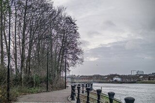
The East Bank Stretch Of The Lagan Opposite the Gasworks
EXPLORING THE EAST BANK STRETCH OPPOSITE THE GASWORKS IN BELFAST [WHILE STORM SWEPT ACROSS THE ISLAND DECEMBER 2025]
Photography in the Teeth of a Gale
Exploring Belfast in December brings a crisp, festive charm, but my photography expedition along the East Bank of the River Lagan coincided with severe weather: Storm Bram, which swept across Ireland on 8 and 9 December 2025. With gale-force winds whipping along the water and driving rain making photography close to impossible, the city stood entirely deserted. There was not a person, dog, or cat to be seen.
For a photographer, however, extreme weather brings a distinct silver lining. Free from crowds and unwelcome attention, I was able to document the city’s stark, atmospheric industrial edges in complete solitude.
GEAR NOTE: For this session, I relied on a newly acquired Fujifilm X100VI. Having attached non-weather-sealed lens adapters, moisture penetrated the housing, fogging the internal glass. While the resulting shots carried a soft, atmospheric mist rather than crisp focus, they captured the tempestuous mood of the river perfectly. │
The weather eventually grew so fierce that a nearby construction crew advised me to seek shelter within the hour—a piece of advice I wisely followed after securing my shots.
The Mystery Structure Opposite the Gasworks
Standing on the East Bank promenade—directly opposite the historic Gasworks complex—two intriguing features dominate the view:
The River Structure: A moss-covered, brick-and-iron edifice standing mid-river, complete with rusted gantry rails that give it the distinct silhouette of a derelict Victorian bridge.
The Public Art: A striking modern steel sculpture (that is not a sculpture) situated further along towards the Ormeau Embankment (the subject of a separate exploration into the "Ravenhill Gateway to Nowhere").
Asking local hotel staff about the mid-river structure yielded little clarity. Most assumed it was simply the abandoned remnant of an old railway or pedestrian crossing. However, watching maintenance crews battle the storm surge to position temporary flood barriers revealed its true identity: The McConnell Weir.
A Solution to a "Stinking" Problem
Built in 1937, the McConnell Weir was commissioned by the Belfast Corporation to tackle a longstanding public health crisis.
Historical Context: The Tidal Lagan Problem
Low Tide ► Exposed vast mudflats along the urban riverbed.
Summer Heat► Decomposing organic matter released pungent sulphurous gas.
Solution ► McConnell Weir built to impound water and drown the mud.
While the weir successfully submerged the mudflats and improved the city's waterfront aesthetics, it inadvertently created a secondary environmental challenge: a "salt wedge." Heavy saltwater trapped at the bottom depleted oxygen levels in the river, harming aquatic life.
This eventually led to the construction of the larger, modern Lagan Weir downstream in 1994 (famous for its adjacent "Big Fish" sculpture). With the new weir managing overall river levels, the McConnell Weir was largely retired, left to age gracefully as a quiet, green-draped monument in the centre of the river.
From Industrial Relic to Modern Storm Sentinel
Despite its aged appearance, the McConnell Weir is far from obsolete. Under the Belfast Tidal Flood Alleviation Scheme, this 1930s engineering remnant plays a vital role in protecting the modern city:
Structural Anchor: Its deep-rooted brick piers and heavy foundations provide an ideal anchor point for deploying mobile flood barriers during extreme weather events.
Tidal Choke Point: During severe tidal surges—such as those brought on by Storm Bram in December 2025—the infrastructure surrounding the weir restricts excess water flow, preventing the Lagan from overtopping its banks into vulnerable residential areas like Ravenhill and the Short Strand.
The top metal framework—often mistaken for a pedestrian footbridge—was actually an industrial maintenance gantry housing winches used to raise and lower the original steel sluice gates.
Navigating the East Bank: Access & Tips for Visitors
Reaching this stretch of the river can confuse first-time visitors due to the layout of nearby transport infrastructure.
Access Notes:
The Entrance Point: The primary pedestrian entry to the East Bank Walkway (Lagan East Promenade) is located on Ormeau Embankment, right beside the Asia Supermarket and the Ozone Complex.
The Northern Dead-End: Walking north along the path towards East Bridge Street/Lanyon Place brings you beneath railway arches and bridge abutments where the path terminates. There is no direct stair or ramp access onto East Bridge Street itself.
Local Nomenclature: Locals and city cycling maps refer to this section variously as the Ravenhill Reach Path, the Lagan East Promenade, or simply the Asia Supermarket Riverside Walk.
Photography in the Teeth of a Gale
Exploring Belfast in December brings a crisp, festive charm, but my photography expedition along the East Bank of the River Lagan coincided with severe weather: Storm Bram, which swept across Ireland on 8 and 9 December 2025. With gale-force winds whipping along the water and driving rain making photography close to impossible, the city stood entirely deserted. There was not a person, dog, or cat to be seen.
For a photographer, however, extreme weather brings a distinct silver lining. Free from crowds and unwelcome attention, I was able to document the city’s stark, atmospheric industrial edges in complete solitude.
GEAR NOTE: For this session, I relied on a newly acquired Fujifilm X100VI. Having attached non-weather-sealed lens adapters, moisture penetrated the housing, fogging the internal glass. While the resulting shots carried a soft, atmospheric mist rather than crisp focus, they captured the tempestuous mood of the river perfectly. │
The weather eventually grew so fierce that a nearby construction crew advised me to seek shelter within the hour—a piece of advice I wisely followed after securing my shots.
The Mystery Structure Opposite the Gasworks
Standing on the East Bank promenade—directly opposite the historic Gasworks complex—two intriguing features dominate the view:
The River Structure: A moss-covered, brick-and-iron edifice standing mid-river, complete with rusted gantry rails that give it the distinct silhouette of a derelict Victorian bridge.
The Public Art: A striking modern steel sculpture (that is not a sculpture) situated further along towards the Ormeau Embankment (the subject of a separate exploration into the "Ravenhill Gateway to Nowhere").
Asking local hotel staff about the mid-river structure yielded little clarity. Most assumed it was simply the abandoned remnant of an old railway or pedestrian crossing. However, watching maintenance crews battle the storm surge to position temporary flood barriers revealed its true identity: The McConnell Weir.
A Solution to a "Stinking" Problem
Built in 1937, the McConnell Weir was commissioned by the Belfast Corporation to tackle a longstanding public health crisis.
Historical Context: The Tidal Lagan Problem
Low Tide ► Exposed vast mudflats along the urban riverbed.
Summer Heat► Decomposing organic matter released pungent sulphurous gas.
Solution ► McConnell Weir built to impound water and drown the mud.
While the weir successfully submerged the mudflats and improved the city's waterfront aesthetics, it inadvertently created a secondary environmental challenge: a "salt wedge." Heavy saltwater trapped at the bottom depleted oxygen levels in the river, harming aquatic life.
This eventually led to the construction of the larger, modern Lagan Weir downstream in 1994 (famous for its adjacent "Big Fish" sculpture). With the new weir managing overall river levels, the McConnell Weir was largely retired, left to age gracefully as a quiet, green-draped monument in the centre of the river.
From Industrial Relic to Modern Storm Sentinel
Despite its aged appearance, the McConnell Weir is far from obsolete. Under the Belfast Tidal Flood Alleviation Scheme, this 1930s engineering remnant plays a vital role in protecting the modern city:
Structural Anchor: Its deep-rooted brick piers and heavy foundations provide an ideal anchor point for deploying mobile flood barriers during extreme weather events.
Tidal Choke Point: During severe tidal surges—such as those brought on by Storm Bram in December 2025—the infrastructure surrounding the weir restricts excess water flow, preventing the Lagan from overtopping its banks into vulnerable residential areas like Ravenhill and the Short Strand.
The top metal framework—often mistaken for a pedestrian footbridge—was actually an industrial maintenance gantry housing winches used to raise and lower the original steel sluice gates.
Navigating the East Bank: Access & Tips for Visitors
Reaching this stretch of the river can confuse first-time visitors due to the layout of nearby transport infrastructure.
Access Notes:
The Entrance Point: The primary pedestrian entry to the East Bank Walkway (Lagan East Promenade) is located on Ormeau Embankment, right beside the Asia Supermarket and the Ozone Complex.
The Northern Dead-End: Walking north along the path towards East Bridge Street/Lanyon Place brings you beneath railway arches and bridge abutments where the path terminates. There is no direct stair or ramp access onto East Bridge Street itself.
Local Nomenclature: Locals and city cycling maps refer to this section variously as the Ravenhill Reach Path, the Lagan East Promenade, or simply the Asia Supermarket Riverside Walk.
OPPOSITE THE LAGAN GASWORKS