I USED A SONY A7RVI WITH A SONY FE 28-70MM GM LENS 10 JULY 2026
A GALLERY OF STREET ART MURALS AT GRAND CENTRAL STATION [BELFAST FRIDAY 10 JUNE 2026]
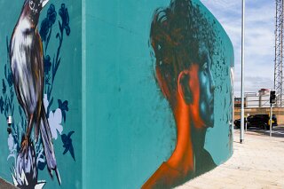
I photographed these murals as I was waiting for my train journey back to Dublin.
I caught an incredibly specific window known locally as the "Twelfth Fortnight." The 12th of July is a major public holiday marking the Battle of the Boyne, characterised by large Orange Order parades.
The week leading up to it is historically a ghost period for standard business and domestic tourism.A huge portion of Belfast’s population actively leaves the city for vacations to the Republic of Ireland, Spain, or Scotland to avoid the closures, traffic restrictions, and political tensions. However, all of this worked to my advantage as it was much easier to photograph most aspects of the city.
The landscape surrounding Belfast Grand Central Station has undergone one of the most significant architectural and cultural shifts the city has seen in decades. What was once a largely industrial and heavily divided transport corridor at the intersection of Durham Street and Grosvenor Road has transitioned into a massive public gateway. Central to this transformation is a vast open-air street art gallery that bridges Belfast's historic murals with contemporary, forward-looking community expressions.
The Street Art and the Artists
The street art framing the station—particularly through major public art initiatives like the When Walls Speak Welcome project (launched in early 2026)—was curated to give local youth and professional street artists a collaborative voice in shaping how the city greets millions of annual visitors.
Delivered by Translink in partnership with the arts organisation Daisychain (co-directed by Adam Turkington), the project positioned schoolchildren from seven local cross-community schools as "co-authors" alongside prominent Northern Irish and international artists.
The gallery features a diverse line-up of renowned artists whose works reflect themes of connection, nature, and shared identity:
Wee Nuls (Nuala Convery): A staple of the Belfast street art scene for over a decade, her signature mural features a girl adorned with the wings of a starling. Inspired by the famous murmuration over the city's Albert Bridge, the piece references themes of "rising flight and transformation," reflecting both the children’s growth and the city's evolution.
Kerrie Hanna, Rhea (Lost Lines), and Imogen Donegan: This trio collaborated on a connected, large-scale leafy design along Durham Street. Incorporating an eco-focus inspired by local primary schools, their artwork brings green, natural imagery into an otherwise urban environment, featuring "Gulliver’s Travels-esque" miniature characters journeying toward the station.
Danni Simpson & Conor McClure: Both contributed distinct vibrant murals that incorporate local typography, positive affirmations, and organic shapes that intentionally depart from the highly politicised mural traditions of Belfast's past.
Other Noted Contributors: Over successive "paint jams" and international festivals like Hit the North, the extended walls have seen installations from artists such as Emic, FGB, Aches, Lidia Cao, and Annatomix, transforming the concrete retaining walls into a modern tapestry of photorealism, abstract geometries, and illustrative fantasy.
History and Transformation of the Streets
Historically, Durham Street and Grosvenor Road sat at a complex urban junction. This area was defined by the legacy of the River Blackstaff (the saltwater river from which the locality takes its name), the linen industry, and the historic Boyne Bridge. Built in 1936 to replace an even older 17th-century structure, the Boyne Bridge traditionally connected the working-class Sandy Row enclave to the rest of the city centre. During the Troubles, these streets acted as stark transit lines bordering deeply segregated communities.
The development of Belfast Grand Central Station (which opened its main phase in late 2024 as the largest integrated transport hub on the island of Ireland) completely dismantled this old topography. To clear space for the multi-million-pound transport interchange and its accompanying Saltwater Square public realm, the historic Boyne Bridge was demolished in 2025.
The streets have been completely reconfigured into pedestrian-friendly walkways, integrated cycle lanes, and high-quality active travel corridors designed to shift Belfast away from car-dependency and toward sustainable transport.
Local Reactions: Connection vs. Displacement
The reaction from local communities to this massive redevelopment has been deeply mixed, highlighting the sensitive nature of urban regeneration in Belfast.
On one hand, civic groups, environmentalists, and commercial bodies have widely praised the development. The inclusion of cross-community schools in creating the murals has been hailed as a triumph for inclusivity, ensuring that the working-class neighbourhoods flanking the station feel a sense of ownership over the new gateway.
On the other hand, the project sparked intense friction, particularly regarding the loss of physical heritage. Residents' groups—most notably the Blackstaff Residents’ Association representing the Sandy Row area—vehemently opposed the demolition of the 1936 Boyne Bridge.
When a central 9-metre-high public sculpture named Reflections (designed by Kevin Killen) was unveiled in Saltwater Square in May 2026, local reaction was highly critical. While the sculpture incorporates original structural steel sections salvaged from the demolished bridge and utilizes the Japanese Kintsugi philosophy of repairing broken items to signify resilience, community spokespersons labelled it a "missed opportunity." Some residents felt the abstract sculpture was a poor substitute for the lost bridge and symbolised authorities "turning their backs" on local heritage.
Infrastructure NI
Despite these underlying tensions, concessions such as the integration of the bridge's old lampposts into the public walkways and renaming a segment of the road to Boyne Bridge Place have served as nods to the area's complex past, leaving the street art gallery to act as a vital, neutral bridge between yesterday's history and tomorrow's Belfast.
Strictly speaking from a structural and geographic perspective, the concrete and steel bridge demolished in 2025 was built in 1936, spanned a railway line, not a river, and was physically located over 70 miles away from the River Boyne in County Meath.
However, the reason it became a focal point of intense heritage friction comes down to local tradition, nomenclature, and what lay buried beneath it.
1. The Direct Connection to the Battle of the Boyne
While the 1936 bridge had no physical connection to the River Boyne, it had a massive symbolic and historical connection to King William III (William of Orange) and his march to the Battle of the Boyne in 1690.
The 1640s Saltwater Bridge: Long before the railways existed, the Blackstaff River flowed through this area. In the 1640s, a stone structure called the Saltwater Bridge (or Great Bridge of Belfast) was built across it.
The 1690 Crossing: Local history and strong Ulster loyalist tradition hold that on 19 June 1690, after landing at Carrickfergus, King William III and his army marched south toward the Battle of the Boyne, crossing this exact Saltwater Bridge at Sandy Row.
The Railway and the Name: In 1863, a new bridge was built just north of the old river crossing to span the expanding Belfast–Lisburn railway line. To honour the local King William tradition, this new railway bridge was officially named the Boyne Bridge.
2. What Happened in 1936?
When the bridge was heavily reconstructed and widened in 1936, the engineers didn't completely destroy the older crossings. Instead, they built the new road right over the top of the 17th-century site. The ancient 1640s Saltwater Bridge was effectively swallowed up and incorporated into the concrete foundations of the 1936 Boyne Bridge's southern approach road.
An archaeological survey confirmed that pieces of the original 17th-century whinstone arches crossed by King William III were still intact, buried 2 to 3 metres beneath the tarmac where Sandy Row met the bridge.
Why the friction occurred
This explains why the Department for Communities ultimately refused to grant the 1936 bridge "listed status" (agreeing with the view that the 1930s concrete structure lacked unique architectural merit), while local residents fought fiercely to save it. For the local Sandy Row community, tearing down the Boyne Bridge wasn't just about removing 1930s concrete—it meant dismantling a symbol named after a defining event in their cultural identity and risking the destruction of the 380-year-old historic crossing buried underneath it.
I photographed these murals as I was waiting for my train journey back to Dublin.
I caught an incredibly specific window known locally as the "Twelfth Fortnight." The 12th of July is a major public holiday marking the Battle of the Boyne, characterised by large Orange Order parades.
The week leading up to it is historically a ghost period for standard business and domestic tourism.A huge portion of Belfast’s population actively leaves the city for vacations to the Republic of Ireland, Spain, or Scotland to avoid the closures, traffic restrictions, and political tensions. However, all of this worked to my advantage as it was much easier to photograph most aspects of the city.
The landscape surrounding Belfast Grand Central Station has undergone one of the most significant architectural and cultural shifts the city has seen in decades. What was once a largely industrial and heavily divided transport corridor at the intersection of Durham Street and Grosvenor Road has transitioned into a massive public gateway. Central to this transformation is a vast open-air street art gallery that bridges Belfast's historic murals with contemporary, forward-looking community expressions.
The Street Art and the Artists
The street art framing the station—particularly through major public art initiatives like the When Walls Speak Welcome project (launched in early 2026)—was curated to give local youth and professional street artists a collaborative voice in shaping how the city greets millions of annual visitors.
Delivered by Translink in partnership with the arts organisation Daisychain (co-directed by Adam Turkington), the project positioned schoolchildren from seven local cross-community schools as "co-authors" alongside prominent Northern Irish and international artists.
The gallery features a diverse line-up of renowned artists whose works reflect themes of connection, nature, and shared identity:
Wee Nuls (Nuala Convery): A staple of the Belfast street art scene for over a decade, her signature mural features a girl adorned with the wings of a starling. Inspired by the famous murmuration over the city's Albert Bridge, the piece references themes of "rising flight and transformation," reflecting both the children’s growth and the city's evolution.
Kerrie Hanna, Rhea (Lost Lines), and Imogen Donegan: This trio collaborated on a connected, large-scale leafy design along Durham Street. Incorporating an eco-focus inspired by local primary schools, their artwork brings green, natural imagery into an otherwise urban environment, featuring "Gulliver’s Travels-esque" miniature characters journeying toward the station.
Danni Simpson & Conor McClure: Both contributed distinct vibrant murals that incorporate local typography, positive affirmations, and organic shapes that intentionally depart from the highly politicised mural traditions of Belfast's past.
Other Noted Contributors: Over successive "paint jams" and international festivals like Hit the North, the extended walls have seen installations from artists such as Emic, FGB, Aches, Lidia Cao, and Annatomix, transforming the concrete retaining walls into a modern tapestry of photorealism, abstract geometries, and illustrative fantasy.
History and Transformation of the Streets
Historically, Durham Street and Grosvenor Road sat at a complex urban junction. This area was defined by the legacy of the River Blackstaff (the saltwater river from which the locality takes its name), the linen industry, and the historic Boyne Bridge. Built in 1936 to replace an even older 17th-century structure, the Boyne Bridge traditionally connected the working-class Sandy Row enclave to the rest of the city centre. During the Troubles, these streets acted as stark transit lines bordering deeply segregated communities.
The development of Belfast Grand Central Station (which opened its main phase in late 2024 as the largest integrated transport hub on the island of Ireland) completely dismantled this old topography. To clear space for the multi-million-pound transport interchange and its accompanying Saltwater Square public realm, the historic Boyne Bridge was demolished in 2025.
The streets have been completely reconfigured into pedestrian-friendly walkways, integrated cycle lanes, and high-quality active travel corridors designed to shift Belfast away from car-dependency and toward sustainable transport.
Local Reactions: Connection vs. Displacement
The reaction from local communities to this massive redevelopment has been deeply mixed, highlighting the sensitive nature of urban regeneration in Belfast.
On one hand, civic groups, environmentalists, and commercial bodies have widely praised the development. The inclusion of cross-community schools in creating the murals has been hailed as a triumph for inclusivity, ensuring that the working-class neighbourhoods flanking the station feel a sense of ownership over the new gateway.
On the other hand, the project sparked intense friction, particularly regarding the loss of physical heritage. Residents' groups—most notably the Blackstaff Residents’ Association representing the Sandy Row area—vehemently opposed the demolition of the 1936 Boyne Bridge.
When a central 9-metre-high public sculpture named Reflections (designed by Kevin Killen) was unveiled in Saltwater Square in May 2026, local reaction was highly critical. While the sculpture incorporates original structural steel sections salvaged from the demolished bridge and utilizes the Japanese Kintsugi philosophy of repairing broken items to signify resilience, community spokespersons labelled it a "missed opportunity." Some residents felt the abstract sculpture was a poor substitute for the lost bridge and symbolised authorities "turning their backs" on local heritage.
Infrastructure NI
Despite these underlying tensions, concessions such as the integration of the bridge's old lampposts into the public walkways and renaming a segment of the road to Boyne Bridge Place have served as nods to the area's complex past, leaving the street art gallery to act as a vital, neutral bridge between yesterday's history and tomorrow's Belfast.
Strictly speaking from a structural and geographic perspective, the concrete and steel bridge demolished in 2025 was built in 1936, spanned a railway line, not a river, and was physically located over 70 miles away from the River Boyne in County Meath.
However, the reason it became a focal point of intense heritage friction comes down to local tradition, nomenclature, and what lay buried beneath it.
1. The Direct Connection to the Battle of the Boyne
While the 1936 bridge had no physical connection to the River Boyne, it had a massive symbolic and historical connection to King William III (William of Orange) and his march to the Battle of the Boyne in 1690.
The 1640s Saltwater Bridge: Long before the railways existed, the Blackstaff River flowed through this area. In the 1640s, a stone structure called the Saltwater Bridge (or Great Bridge of Belfast) was built across it.
The 1690 Crossing: Local history and strong Ulster loyalist tradition hold that on 19 June 1690, after landing at Carrickfergus, King William III and his army marched south toward the Battle of the Boyne, crossing this exact Saltwater Bridge at Sandy Row.
The Railway and the Name: In 1863, a new bridge was built just north of the old river crossing to span the expanding Belfast–Lisburn railway line. To honour the local King William tradition, this new railway bridge was officially named the Boyne Bridge.
2. What Happened in 1936?
When the bridge was heavily reconstructed and widened in 1936, the engineers didn't completely destroy the older crossings. Instead, they built the new road right over the top of the 17th-century site. The ancient 1640s Saltwater Bridge was effectively swallowed up and incorporated into the concrete foundations of the 1936 Boyne Bridge's southern approach road.
An archaeological survey confirmed that pieces of the original 17th-century whinstone arches crossed by King William III were still intact, buried 2 to 3 metres beneath the tarmac where Sandy Row met the bridge.
Why the friction occurred
This explains why the Department for Communities ultimately refused to grant the 1936 bridge "listed status" (agreeing with the view that the 1930s concrete structure lacked unique architectural merit), while local residents fought fiercely to save it. For the local Sandy Row community, tearing down the Boyne Bridge wasn't just about removing 1930s concrete—it meant dismantling a symbol named after a defining event in their cultural identity and risking the destruction of the 380-year-old historic crossing buried underneath it.
A GALLERY OF MURALS